Geographic Mapping
In geographical networks the layout of nodes is fixed and determined by some coordinates.
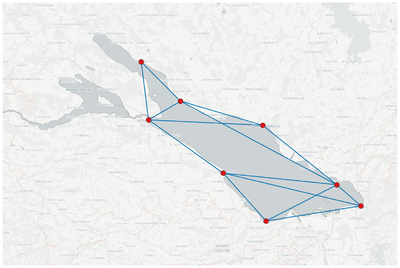
The geographic mapping allows the representation of geographical networks, whose node positions are characterized by latitude and longitude, over the corresponding map.
The map is downloaded from OpenStreetMaps, and therefore an internet connection is required when plotting a geographic network for the first time. When the position of the nodes is modified to avoid node overlapping, then the original position of the node can be recovered unchecking the option map nodes and visualizing the network. In this case the background map is not re-downloaded from the internet. Thus, an internet connection is not necessary.
Several map styles with a specific area and level of detail can be selected by the user.
| 9 students at the University of Konstanz living in the Bodensee region and communicating during the semester break | |

|
Example Data
The communication network of 9 students at the University of Konstanz during the semester break:
- the '''adjacency matrix''' of the communication network above
- the '''Coordinates''' of the city where the students live